

A second weekly run of the ECMWF monthly forecast has been introduced, running every Monday (00 UTC) to provide an update to the main Thursday run. Products are provided to the ECMWF Member and Co-operating States and to commercial users. The monthly forecasts are an integral part of the Ensemble Prediction System (EPS) and provide outlooks up to 32 days ahead.
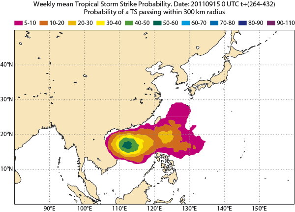
Forecast probability in per cent that a tropical storm will strike within 300 km during the calendar week 26 September to 2 October 2011. Probabilities are computed from the 51 members of the real-time monthly forecast started from 15 September (forecast days 12 to 18). The predictability at this time range comes mostly from sea-surface temperature anomalies and the phase of the Madden-Julian Oscillation. This predicted storm contributed to the devastating flooding over Thailand.
ECMWF uses its expertise in numerical modelling and data assimilation to produce some of the best available numerical predictions of intra-seasonal weather. An important source of predictability over Europe in the 10-30 day range is believed to originate in the tropics, from the so-called Madden-Julian Oscillation (MJO). The MJO is a 40-50 day oscillation in tropical convection. The EPS monthly forecast displays strong skill in predicting the evolution of the MJO up to 3-4 weeks in advance.
The ECMWF monthly forecasts are extensions of the medium-range forecasts from the EPS and are produced using persisted sea-surface temperature (SST) anomalies until day 10 and SSTs predicted by an ocean model from day 10 onwards. The resulting forecast products are based on a combination of two components:
- The real-time forecasts issued every Thursday and Monday: an ensemble of 51 members, with a horizontal resolution of about 60 km.
- A set of re-forecasts: integrations from start dates at the same time of year for the past 18 years, made with the current forecast model, providing a model climatology that is used to calibrate the real-time forecasts. Specific re-forecasts are not produced for the Monday run. Instead, a combination of two sets of the Thursday re-forecasts, for the previous Thursday and the following Thursday, is used in the generation of the weekly-mean forecast anomalies.
Further details about the monthly system are available in the monthly forecasting documentation.
The raw numerical data and graphical outputs from the EPS monthly forecasts are available to the national meteorological services of the ECMWF Member States and Co-operating States and to commercial users, who use the information to produce forecast statements or products targeted at the general public and other user groups, such as governmental authorities or the energy sector.
A new set of web pages shows graphical products from both Thursday and Monday runs. Time-averaged fields are shown for the same seven-day calendar weeks (Monday-Sunday) as for the current Thursday run.
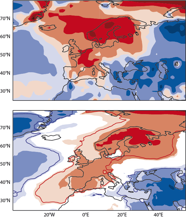
Mean 2m temperature anomalies for the calendar week 31 October to 6 November 2011. Top: verifying analysis; bottom: forecast for this period from Monday 24 October (ensemble mean anomaly for forecast days 8 to 14)