Louise Nuijens, ECMWF Fellow and Assistant Professor at Delft University of Technology (TU Delft)
My research group at TU Delft, funded through a European Research Council starting grant (CloudBrake), focuses on how winds in the lower atmosphere are influenced by shallow convective clouds. Our interest is motivated by the idea that even the smallest clouds do not simply drift along with the wind, but are actively influencing winds through the cloud-scale and mesoscale circulations in which they are embedded – a process we call convective momentum transport (CMT).
Becoming an ECMWF Fellow in mid-2018 was a great opportunity to strengthen my existing collaboration with colleagues at ECMWF, and in particular with Irina Sandu and the Physical Processes Team she is leading. It also represents a unique chance to contribute to understanding inaccuracies in ECMWF’s weather forecasts and ultimately to improve them.
From spring to autumn, while staring outside the window of my home office, I have seen many shallow cumulus clouds drift by, which are quite typical for the Netherlands. They reminded me almost daily of my last trip abroad. A quick visit to Barbados for the EUREC4A (Elucidating the Role of Clouds-Circulation Coupling in Climate) field study. Eating grilled fish, getting windblown on the beach, discussing with Irina how EUREC4CA observations can be used to improve weather forecasts, and gaining enough inspiration on what drives the wind, just in time for what became a long stay at home.

A view from Barbados. Photo: Louise Nuijens.
Barbados: observing winds above the surface
Many observations were collected upstream of Barbados during EUREC4A (20 January–20 February 2020), but the ones we have been keen on exploring so far are the wind profiles from the hundreds of dropsondes and radiosondes. Wind measurements at levels above the surface are rare out over the open ocean, but are important to understand what sets the wind near the surface.
Short-range forecast surface winds in the ERA5 reanalysis and in ECMWF operational forecasts are characterised by excessive mean zonal winds (too easterly in the tropics) and weak mean meridional winds (not equatorward enough in the trade regions) compared to ASCAT (advanced scatterometer) satellite observations. This means that the Integrated Forecasting System (IFS), used to produce both ECMWF forecasts and ERA5, misses some friction near the surface. In a sensitivity experiment, turning off CMT by shallow convection, a significant reduction of the wind turning bias is found. But the source of the bias does not need to be CMT: CMT might merely act to communicate a bias in wind, established at higher levels, towards the surface.
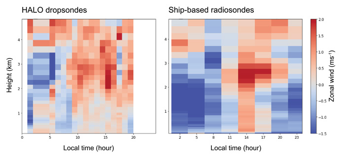
EUREC4A observations provide a unique opportunity to explore the wind biases in the IFS in more detail. During the virtual visit of Alessandro Savazzi, a member of my group, to ECMWF over the past six months, we compared the hourly wind profiles collected during EUREC4A with ECMWF short-range forecasts and ERA5, zooming in on errors made at different levels and times of the day. Surprisingly, we found that in operational ECMWF forecasts excessive easterly winds are most pronounced in the lower cloud layer (1–2 km) in the night and early morning, while above 2 km during daytime, zonal winds are much too weak (Figure 1). The error above 2 km remains with shallow CMT turned off, suggesting that erroneous wind shear and poorly constrained pressure gradients might also play a role.

Figure 1: Composite of the zonal wind error throughout the day as a function of height during EUREC4A (Jan–Feb 2020). The errors are calculated from day 2 ECMWF forecasts minus observations, using HALO dropsondes (left), which were rare during nighttime, and using ship-based radiosondes (right), which sampled both day and night. Values are averaged over the EUREC4A-Circle, defined by the circular airborne sounding array centered at 57:7W, approximately 200 km in diameter.
Large-eddy simulations
One of our next steps is to use large-eddy simulations (LES), which have a horizontal resolution of a tenth to hundreds of metres, to unravel individual processes. EUREC4A benefits from many coordinated modelling activities, including LES set-ups with more realistic open boundaries derived from meteorological analyses. These are a real advance, as the flux of momentum appears underestimated in traditional LES with cyclic boundary conditions, something we hypothesise to arise from the absence of mesoscale circulations.
The high resolution of the LES is key to address another challenge for parametrizations of momentum mixing used in weather forecast models such as ECMWF’s IFS: the relative roles of small-scale shear-driven turbulence versus convective and mesoscale motions. One of the main insights we have gained from pre-EUREC4A simulations is that the effect of CMT on the mean wind may be more pronounced below the clouds, in the turbulent mixed-layer, than within the clouds.
Closer to home, we are already focusing on the behavior of the turbulence and convection schemes of the IFS on days with shallow cumulus in the Netherlands over Cabauw (now known as the Ruisdael Observatory, named after the 17th century painter Jacob van Ruisdael, famous for his cloudy skies).
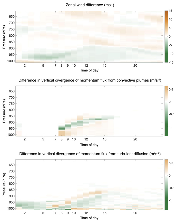
Over land (including over Europe), the IFS also has a long-standing wind speed and wind turning bias. In the framework of Beatrice Saggiorato’s PhD, we are running the Dutch LES model with the same large-scale forcing as the IFS, and comparing the influence of turbulence and convection on the zonal wind in the LES and in the IFS forecasts. A complex picture emerges, in which forecast errors in the surface layer differ from errors in the rest of the mixed layer, and errors from the turbulence and convection scheme can compensate (Figure 2). The transition from nighttime to daytime plays a role, and the coupling of clouds to the surface through radiative processes poses an additional challenge.

Zonal wind difference (IFS – DALES) over Cabauw from model simulations of 5 Sept 2016 (top), as well as the differences in the tendency of zonal wind from the vertical divergence of momentum flux (IFS - DALES) produced by convective plumes (middle) and by turbulent diffusion (bottom). DALES is the Dutch Atmospheric large-eddy simulation.
As Barbados memories fade, models and observations from EUREC4A are analysed for sugar, gravel, fish and flowers and data keeps pouring in. The longing for real fish remains, but as fronts and cold air outbreaks promise to deliver plenty of convective clouds over the Netherlands even during autumn, my home office will not be dull.
