Having completed a World Meteorological Organization (WMO) fellowship at ECMWF, it is a pleasure to look back and share my reflections. The fellowship scheme between the WMO and ECMWF is part of a wider WMO Fellowship Programme that provides specialised training placements to develop capacity in least-developed and developing countries.
The one-year fellowship at ECMWF provided firsthand experience of the day-to-day operations and the final stages of the roll-out of the new Integrated Forecasting System (IFS) Cycle 48r1 in June 2023. It also provided the opportunity to take part in training courses at the Centre and in forums with experts from across the globe.
Working closely with the Forecast Department, a research project was formulated to improve the retrieval and processing of model data and expand computer programming skills. The study focused on assessing the forecast skill of the IFS in predicting the onset of monsoon winds over the Maldives area.
The monsoon onset is declared by the Maldives Meteorological Service (MMS) based on observations against a set of criteria. These criteria include the reversal of the lower-level zonal (east–west) wind direction with a sustained average wind speed of 10 knots or more for two consecutive days over the three regions of the country. The southwest monsoon and the northeast monsoon are triggered by the propagation/withdrawal of the Intertropical Convergence Zone (ITCZ) over the country around the first week of May and in mid‑to‑late December, respectively. The onset of the southwest monsoon over the Maldives is the first indication of the onset of the greater Asian monsoon over the region. Therefore, increasing the forecasting skill of the MMS would have regional benefits as well.
How good is ERA5 as a proxy for observations?
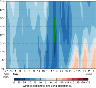
The first question for the study was to analyse how to process data from ECMWF’s ERA5 reanalysis as a proxy for observation data and how close this was to the ground reality. To address this, the ERA5 data was processed and plotted using area and line Hovmöller averaging, each for two levels (1,000 and 850 hPa). As the country is centered along 73°E, a narrowing longitude band starting from 60–70°E was tested. The longitude band 75–70°E was chosen for the Hovmöller averaging as a reasonable representation whilst allowing for enough data to go into the computation. The parameter showing the resultant wind (speed) and the zonal wind sign was computed to reflect the monsoon onset criteria. These composite figures were then analysed against the past 22 years of southwest monsoon-declared dates for three regions of the Maldives by the MMS (see the first figure). The analysis looked at how many of these cases for each region satisfied the onset criteria, in other words the hit rate of ERA5 compared to formal monsoon onset dates declared by the MMS.

For area Hovmöller averaging at 1,000 hPa, over 70% of ERA5 hits were in agreement for the southern region, and 57% and 48% for the north and central regions, respectively (see the table). The difference in values across the regions can be attributed to the fact that the southwest onset declaration is strongly focused on the southern region, being the first area of onset over the country (as the ITCZ moves northwards); difficulties in clearly defining the regional boundaries; plus evolving practices over the two decades. As the results for the line Hovmöller averaging were fairly similar, for simplicity, the study continued using ERA5 area-averaged Hovmöller at 1,000 hPa as a good proxy for the observations. A similar study was not possible for the northeast monsoon due to the lack of long-term onset declaration dates for the monsoon.

How far ahead can the IFS predict monsoon winds?
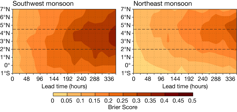
To address this question, medium range ensemble (ENS) reforecast data of the IFS from 2023 (hindcasts consisting of ten perturbed members and a control member) was retrieved for a two-month period centred on average monsoon onsets for the 20‑year period of 2003–2022. The data was processed as area-averaged Hovmöller of the probability of derived parameters consisting of both the resultant wind (speed) and the sign of the zonal wind. A corresponding dataset for each hindcast run was prepared from the reanalysis data. Based on these two datasets, a Brier Score was computed to assess the accuracy of the ENS hindcast for the past 20 years.
While a Brier Score of 0 represents perfect accuracy in probabilistic predictions, a score of 1 indicates that the predicted forecasts are as far from the observation as possible, in this case, the ERA5 values. The analysis for southwest monsoon winds showed an overall Brier Score of less than 0.4 across the 15-day forecast window and a Brier Score of less than 0.25 up to 7 days ahead (see the left-hand panel of the second figure). This indicates that the IFS model has good predictive skill in forecasting the onset of southwest monsoon winds over the Maldives region.

The analysis for northeast monsoon wind onset showed an overall Brier Score of less than 0.3 across the 15-day forecast window and a Brier Score of less than 0.2 up to 10 days ahead (see the right-hand panel of the second figure). This indicates that the IFS model has even better predictive skill in forecasting the onset of northeast monsoon winds over the Maldives region. With this information, during the final stage of the study, a model product was designed for the Maldives region. The product is intended to inform forecasters of the percentage of ECMWF ensemble members from the real-time forecasts that fulfill the monsoon wind onset criteria across the longitude band of 70–75°E from 7°N to 1°S. In addition to forecasting monsoon wind, the product can predict wind burst episodes related to large-scale variability, such as the Madden–Julian Oscillation.
The fellowship has undoubtedly opened up a new avenue for the MMS to maximise its uptake of information and guidance from ECMWF, whilst also forging closer cooperations through initiatives such as UN Early Warning for All.
